
3D Mapping Unlocks A New World
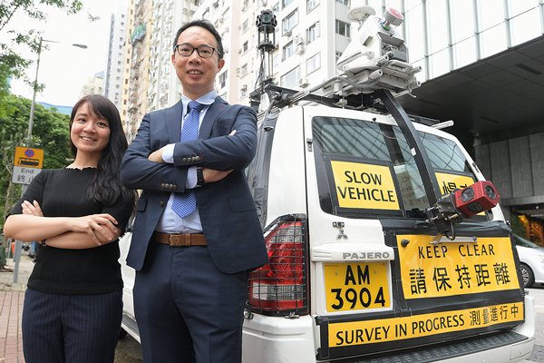
Residents may have seen a distinctive white car, fitted with advanced imaging and sensory gadgetry, on its journey to create the next generation of Hong Kong maps.
As it travels up and down the city’s streets, it records the three-dimensional shapes of buildings ranging from the iconic Convention & Exhibition Centre to the Customs Headquarters Building, and even primary school campuses.
The vehicle, dubbed the Mobile Mapping System, is one of the latest technologies used by the Lands Department to survey the city.
Five pieces of equipment work in concert to collect detailed information for the 3D City Map - a core component of the digital infrastructure underpinning Hong Kong’s smart city development.
A high-resolution camera on top of the vehicle captures 360-degree images and a 3D laser scanner collects spatial measurements. An inertial navigation system and a global navigation satellite system receiver provide precise positioning.
Lands Department Assistant Land Surveyor Charlie Hung said one of the biggest advantages of this system is its ability to quickly and efficiently acquire data, which can be used to enrich 3D models and enhance existing maps.
“We can enhance the attributed information of our basic map. For example, the lamppost number, the building name or the street number.”
Drones are also used to map the city, she added. However, air surveying may not be suitable for collecting data from ground level. This is where the Mobile Mapping System vehicle comes into play.
Better data
The 3D City Map is part of the 3D Digital Map Development, which aims to contribute to an innovative, sustainable and smart Hong Kong.
Compared with traditional maps, the 3D City Map can provide more accurate and abundantly better spatial data.
The map will cover the entire city by 2023, serving as a handy tool for analysis and planning, according to Lands Department Land Surveyor Ben Fan.
He said: “Based on the 3D digital map, we can develop various kinds of applications such as land administration, environmental assessment, town planning and also transport and engineering studies.”
The latest transport infrastructures such as the Hong Kong-Zhuhai-Macao Bridge, the Central-Wan Chai Bypass and the Heung Yuen Wai Highway have also been scanned.
In the next stage of the 3D Digital Map Development, the department will create the 3D Indoor Map. As a start, data from 150 buildings in Kowloon East will be collected first before extending to other buildings in the city.
The last stage 3D models of objects such as trees and lampposts for city modelling will be produced.
New Chamber Spurs Precision Testing
Precision timing, acoustic testing and medical technology may serve different sectors, but they all rely on the same i... Read more
Renewed Riverbanks Uplift Community
At the Hung Shui Kiu/Ha Tsuen New Development Area, the Civil Engineering & Development Department (CEDD) is breat... Read more
Youth Spaces Foster Connection
The Home & Youth Affairs Bureau (HYAB) recently launched two interactive youth spaces, offering young people oppor... Read more
Smart Traffic Fund Drives Safer Trips
Facing high population density and rising transport demand, the Government established the $1 billion Smart Traffic Fu... Read more
Port System Enables Seamless Freight
A smart port is one that makes global connections easier through advanced technologies and efficient logistics. Spear... Read more
Harnessing Central Asias Potential
A delegation led by Chief Executive John Lee will visit Kazakhstan and Uzbekistan in June to establish new trade route... Read more